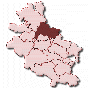
Bad Sooden-Allendorf Bad Sooden-Allendorf
Fotos aus dem Umkreis von Bad Sooden-Allendorf Bad Sooden-Allendorf
Strassen in der Nähe vom Ortsteil Bad Sooden-Allendorf
- Hindenburgplatz (0.11km)
- Am alten Festplatz (0.13km)
- Eschweger Landstraße (0.14km)
- Landgraf-Philipp-Platz (0.14km)
- Am Bahnhof (0.17km)
- Ferdinand-Schlemm-Straße (0.19km)
- Städtersweg (0.2km)
- Landgrafenstraße (0.21km)
- Lindenallee (0.21km)
- Lindenallee (0.21km)
- Am Tor (0.23km)
- Lange Reihe (0.24km)
- Kurhausstraße (0.28km)
- Auf den Teichhöfen (0.3km)
- Holzstad (0.31km)
- Hinter dem Wahl (0.31km)
- Auf dem Herrengraben (0.32km)
- Am Güterbahnhof (0.32km)
- Bahnhofstraße (0.32km)
- Weinreihe (0.32km)
- Brunnenplatz (0.36km)
- Brunnenplatz (0.36km)
- Bertram-Schrot-Straße (0.39km)
- Franzrasen (0.41km)
- Konrad-Adenauer-Allee (0.46km)
- Hilberlachestraße (0.48km)
- Fischerstad (0.52km)
- Am Solgraben (0.52km)
- Fritz-Gottsleben-Straße (0.53km)
- Am Gradierwerk (0.55km)
- Hedwig-Lange-Weg (0.57km)
- Hinter der Mauer (0.57km)
- Balzerbornweg (0.57km)
- Steinweg (0.59km)
| Arbeitsmarktdaten von Bad Sooden-Allendorf, Stadt | |
|---|---|
| Sozialversicherungspflichtige | |
| nach Wohnort | 2357 |
| nach Arbeitsort | 2001 |
| Einpendler | 1075 |
| Auspendler | 1431 |
| Geringfügig Beschäftigte (400€ Basis) | |
| nach Wohnort | 643 |
| nur GeB (Wohnort) | 482 |
| GeB als Nebenjob (Wohnort) | 161 |
| nach Arbeitsort | 638 |
| nur GeB (Arbeitsort) | 474 |
| GeB als Nebenjob (Arbeitsort) | 164 |
| Arbeitslose | ca. 76.92% |
| Gesamt | 295 |
| davon ALG I | 77 |
| davon HARTZ 4 (ALG II) | 218 |
| Frauenquote | 43.39% |
| Männerquote | 56.61% |
| Ausländerquote | 5.76% |
| © Arbeitsagentur u.a. | |
| Fakten zur Gemeinde Bad Sooden-Allendorf, Stadt | |
|---|---|
| Gemeindeschlüssel | 06636001 |
| Regionalschlüssel | 066360001001 |
| Gemeindetyp | Stadt |
| Verwaltung | Magistrat der Stadt Bad Sooden-Allendorf Marktplatz 8 37242 Bad Sooden-Allendorf |
| Bevölkerungsdichte | 116 Ew. je km² |
| Fläche | 73,52 km² |
| Einwohner | 8544 |
| davon weiblich | 4529 |
| davon männlich | 4015 |
| GPS Latitude | 51.268360 |
| GPS Longitude | 9.968690 |
| Vorwahl | 05542, 05604, 05652 |
| Telefonnetz | Witzenhausen, Grossalmerode, Bad Sooden-Allendorf |
| Land | Hessen |
| Regierungsbezirk | Reg.-Bez. Kassel |
| Landkreis | Werra-Meißner-Kreis |
| Gemeinde | Bad Sooden-Allendorf, Stadt |
| Aktive Googlemaps-Karte von Bad Sooden-Allendorf | |
| Aktive Openstreetmap-Karte von Bad Sooden-Allendorf | |
| Steuersätze von Bad Sooden-Allendorf, Stadt | |||
|---|---|---|---|
| Ort | Grundsteuer A | Grundsteuer B | Gewerbesteuerhebesatz |
| Bad Sooden-Allendorf, Stadt | 300 | 300 | 340 |
Gemeinde-Übersichtskarte(n)
Bad Sooden-Allendorf, Stadt


