
Kolpingstraße
Kolpingstraße wird klassifiziert als:
- Verkehrsberuhigter Bereich, Ö: Wohnstraße – Eine Straße in der auf spielende Kinder aufgepasst werden muss, Fußgänger bevorzugt behandelt werden und nur Schrittgeschwindigkeit erlaubt ist. (gelegentlich fälschlich „Spielstraße“ genannt, eine echte solche wäre aber ohne Autos)
Googlekarten
Quelle: OpenStreetMap
| In der Nähe von ,,Kolpingstraße´´ | |
|---|---|
| Bahnhofsanlage | Dortmund Bbf, Dortmund West, Dortmund-Westerholz, Dortmund-Obereving, Dortmund Möllerbrücke, Dortmund Signal Iduna Park, Dortmund Süd, Dortmund Hbf, Güterbahnhof Dortmund-Süd, Dortmund Dortmunderfeld, Dortmund-Eving, Dortmund Stadthaus |
| Bergbaubetrieb | Zeche Tremonia |
| Farm / Landwirtschaft | Hangufer |
| Gebäude | Petrikirche, Synagoge und Gemeindezentrum Prinz-Friedrich-Karl-Straße Dortmund, Sankt Reinoldi, Klinikum Dortmund, Sankt-Johannes-Hospital Dortmund |
| Industrie- und Gewerbefläche | Dortmund |
| Kanal (Schifffahrt) | Dortmund-Ems-Kanal, Kanalhafen |
| Stadion | Stadion Rote Erde, Signal Iduna Park |
| Turm | Florianturm |
Fotos aus der Nähe Kolpingstraße
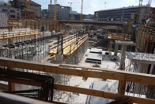
 (von jarikir)
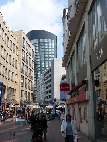


Strassen in der Nähe von ``Kolpingstraße´´
- Kolpingstr. (0.01km)
- Silberstraße (0.06km)
- Schwarze-Brüder-Straße (0.09km)
- Eisenmarkt (0.09km)
- Westenhellweg (0.12km)
- Potgasse (0.13km)
- Mönchenwordt (0.14km)
- Petrikirchhof (0.15km)
- Hansastraße (0.17km)
- Kuhstraße (0.17km)
- Hövelstraße (0.17km)
- Lühringhof (0.18km)
- Petergasse (0.19km)
- Kampstraße (0.19km)
- Martinstraße (0.2km)
- Hansaplatz (0.2km)
- Wißstraße (0.25km)
- Prinzenstraße (0.26km)
- Am Trissel (0.27km)
- Grafenhof (0.28km)
- Katharinenstraße (0.28km)
- Weddepoth (0.28km)
- Markt (0.3km)
- Freistuhl (0.3km)
- Salzgasse (0.31km)
- Brauhausstraße (0.32km)
- Hoher Wall (0.32km)
- Königswall (0.32km)
- Hiltropwall (0.33km)
- Museumsgasse (0.33km)
- Wallstraße (0.34km)
- Schmiedingstraße (0.34km)
- Balkenstraße (0.34km)
- Poststraße (0.36km)
- Bissenkamp (0.37km)
- Hohe Luft (0.37km)
- Gerberstraße (0.41km)
- Lütge Brückstraße (0.42km)
- Johannesstraße (0.43km)
- Brückstraße (0.45km)
- Gnadenort (0.45km)
- Südwall (0.47km)
- Elisabethstraße (0.49km)
- Luisenstraße (0.5km)
- Helle (0.52km)
- Hakenstraße (0.53km)
- Burgtor (0.59km)
- Auf dem Berge (0.63km)
Geografische Punkte und Wege aus OpenStreetmap in der Nähe von ``Kolpingstraße´´
- Kampstraße
- Grafenhof
- Grafenhof
- Johannesstraße
- Weddepoth
- Martinstraße
- U43; U44
- Westenhellweg
- U42
- Thier-Verwaltung
- Katharinenstraße
- Potgasse
- Katharinenstraße
- Petrikirchhof
- Katharinenstraße
- Petrikirchhof
- Petrikirche
- Poststraße
- Petrikirchhof
- Sparkasse Dortmund
- Hövelstraße
- Schauspielhaus
- Hiltropwall
- Stadt- und Landesbibliothek, Zentralbibliothek
- Kuhstraße
- Eisenmarkt
- Opernhaus
- Kolpingstraße
- Kampstraße
- Königswall
- RWE-Tower
- Hohe Straße
- Schwarze-Brüder-Straße
- Chemnitzer Straße
- Propsteihof
- Museum für Kunst und Kulturgeschichte
- Mönchenwordt
- Kampstraße
- Hansastraße
- Schwarze-Brüder-Straße
- Hansastraße
- Hansastraße
- Silberstraße
- Hansastraße
- Lütge Brückstraße
- Gnadenort
- Bissenkamp
- Burgtor
- Stadtgarten
- Prinzenstraße
- metropolradruhr
- Städtische Kliniken
- Städtische Kliniken
- Städtische Kliniken
- Städtische Kliniken
- Kir Royal
- Apotheke Hoher Wall
- Postbank
- Taj Mahal
- Cityhotel Dortmund
- Greenwheels Station
- Martinstraße/Thier-Gelände
- Martinstraße/Thier-Gelände
- Dortmund Hbf
- Dortmund Hbf
- Dortmund Hbf
- Conrad
- Norisbank
- Feldkamp
- Dortmund Hbf S / ZOB
- Hövels Hausbrauerei
- Dortmund Hbf S / ZOB
- Frisör Fiedler
- Dortmund Hbf
- Dortmund Hbf
- Dortmund Hbf S / ZOB
- Dortmund Hbf
- Dortmund Hbf
- Dortmund Hbf S
- Dortmund Hbf
- Dortmund Hbf S
- Dortmund Hbf
- Dortmund Hbf
- Städtische Kliniken
- Village
- Dortmund Hbf S
- Städtische Kliniken
- Dortmund Hbf S
- Hauptbahnhof
- Kleimann
- Targobank
- Städtische Kliniken
- Subway
- Postbank
- Petri Blumen
- Star S Döner
- Dortmund Hauptbahnhof
- Trinkwasserbrunnen
- Dortmund Hbf
- Stadtgarten


