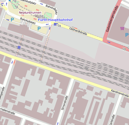
Fürth (Bay) Hbf (Bahnhofsanlage)
Bei(m) Fürth (Bay) Hbf handelt es sich um ein Bahnhofsanlage. Der zugehörige Postleitzahlbereich ist 90763 und gehört somit zum Ort Fürth Südstadt.
Fotos zu(m) Fürth (Bay) Hbf
Gewässer, Gebäude etc. im Umkreis von Fürth (Bay) Hbf
Bahnhofsanlage: Nürnberg Großmarkt (3.21km), Fürth Alte Veste (2.17km), Nürnberg-Doos (2.08km), Fürth-Dambach (1.71km), Bahnhof Nürnberg-Doos (1.81km), Fürth (Bay) Hbf (0km), Fürth Westvorstadt (1.45km), Fürth-Unterfarrnbach (2.48km)
Gebäude: Synagoge Hallemannstraße Fürth (0.88km), Klinikum Fürth (2.12km)
Stadion: Playmobil-Stadion (2.04km)
Verkehrsknoten: Nürnberg/Fürth (1.78km), Fürth-Poppenreuth (1.65km), Fürth-Ronhof (2.98km)
Geografische Punkte und Wege aus OpenStreetmap in der Nähe von ``Fürth (Bay) Hbf´´
- Ottostraße
- Berolzheimerianum (Comödie Fürth)
- Salzstraße
- Schwabacher Straße
- Schwabacher Straße
- Maxstraße
- Schreiberstraße
- Schwabacher Straße
- Marienstraße
- Schwabacher Straße
- Schwabacher Straße
- An der Post
- Schwabacher Straße
- Schwabacher Straße
- Mathildenstraße
- Lessingstraße
- Maxstraße
- Holzstraße
- Sparkasse Fürth
- Maxstraße
- An der Post
- Schwabacher Straße
- Hauptpostamt
- Fichtenstraße
- Karolinenstraße
- Amalienstraße
- Maxstraße
- An der Post
- An der Post
- Rudolf-Breitscheid-Straße
- Bahnhofplatz
- An der Post
- Ludwigstraße
- Bahnhofplatz
- Friedrichstraße
- Bahnhofplatz
- Bahnhofplatz
- Parkplatz an der Post
- Benno-Mayer-Straße
- Bahnhofplatz
- Hallstraße
- Rudolf-Breitscheid-Straße
- Bahnhofplatz
- Bahnhofplatz
- Friedrichstraße
- Gleis 3
- Gustav-Schickedanz-Straße
- Gleis 5
- Gleis 4
- Gleis 2
- "Arschbaggncafe"
- Comödie Fürth
- Mathildenstraße
- ASIA Küche
- Maxstraße
- Woolworth
- mono-ton Schallplattenladen
- Cafe Alex
- Stempel-Eckstein
- Wiehgärtner's
- dm-drogeriemarkt
- Maxstraße Süd
- Sparkasse Fürth
- Targobank
- Postamt
- GameStop
- Fielmann Fürth
- Backwerk Fürth
- Deutsche Bank
- Happy Hairy People
- Optik Schlemmer
- NKD
- Kreuz Apotheke
- Drei-Herren-Denkmal
- Bücher Genniges
- Kochlöffel
- Metzgerei Walk Ludwig
- Bäckerei Feihl
- Hirsch-Apotheke
- Mr. Bleck
- Kamps
- VeroModa/JackJones
- Side Döner
- Juwelier Arthur
- La Tasca
- Fürth Bahnhof
- Fürth Bahnhof
- Norma
- Friedrichstraße
- Subways
- Hauptbahnhof Fürth
- Friedrichs-Apotheke
- Commerzbank
- Fürth (Bayern) Hauptbahnhof
- Hallstraße
- Fürth (Bayern) Hauptbahnhof
- Hauptbahnhof Fürth
- City Kino
- Hauptbahnhof Fürth
- Hauptbahnhof Fürth
Strassen in der Nähe von ``Fürth (Bay) Hbf´´
- Bahnhofplatz (0km)
- Amalienstraße (0km)
- Benno-Mayer-Straße (0km)
- Gabelsbergerstraße (0km)
- Karlstraße (0km)
- Gustav-Schickedanz-Straße (0km)
- Dr.-Martin-Luther-Platz (0km)
- Benditstraße (0km)
- Winklerstraße (0km)
- Rudolf-Breitscheid-Straße (0km)
- Fürther Freiheit (0km)
- An der Post (0km)
- Luisenstraße (0km)
- Königswarterstraße (0km)
- Schreiberstraße (0km)
- Fichtenstraße (0km)
- Ohmstraße (0km)
- Friedrichstraße (0km)
- Maxstraße (0km)
- Simonstraße (0km)
- Stresemannplatz (0km)
- Salzstraße (0km)
- Engelhardtstraße (0km)
- Moststraße (0km)
- Herrnstraße (0km)
- Schwabacher Straße (0km)
- Holzstraße (0km)
Kartenausschnitt von Yahoo


 (von Achates2342)


